


Local Tour Guide in Sri Lanka – Explore the Best Destinations Across the Island
Sri Lanka’s most iconic destinations with a local tour guide. Sri Lanka Holiday Destinations, The Island’s proud history of over 2500 years and the breathtaking diversity of scenery will capture your heart and soul like no other destination. May the time you spend in our Island be filled with exciting experiences – memories of which you will carry long after you leave our shores.
The palms clasped together and a gentle blow of the head accompanies, “Ayubowan”(may you be blessed with long life), Sri Lanka’s gentle gesture of welcome and respect. What may strike you the most about Sri Lanka is its amazing diversity of scenery. It is possible to pass brilliant green paddy fields, sun-bronzed beaches, ancient cities, lively villages, deserted regions, sanctuaries of wildlife in tropical jungles, and hill country tea plantations literally within hours of each other.

Anuradhapura is a major city in Sri Lanka. It is the capital city of North Central Province, Sri Lanka and the capital of Anuradhapura District. Anuradhapura is one of the ancient capitals of Sri Lanka, famous for its well-preserved ruins of an ancient Sri Lankan civilization. It was the third capital of the Kingdom of Rajarata, following the kingdoms of Tambapanni and Upatissa Nuwara.
The city, now a UNESCO World Heritage Site, was the center of Theravada Buddhism for many centuries. The city lies 205 km (127 mi) north of the current capital Colombo in Sri Lanka’s North Central Province, on the banks of the historic Malvathu Oya. It is one of the oldest continuously inhabited cities in the world and one of the eight World Heritage Sites of Sri Lanka. It is believed that from the fourth century BC until the beginning of the 11th century AD it was the capital of the Sinhalese. During this period it remained one of the most stable and durable centers of political power and urban life in South Asia. The ancient city, considered sacred to the Buddhist world, is today surrounded by monasteries covering an area of over sixteen square miles (40 km²).

As the second most ancient of Sri Lankas kingdoms, 800 years ago Polonnaruwa was a thriving commercial and religious centre. The ancient city served as a base for Kings to rule the central plains of Sri Lanka whilst market men haggled for rare goods and the pious preyed at any one of the many temples. The ancient city was declared a World Heritage Site by UNESCO in 1982.
Polonnaruwa is a testament to the discipline and greatness of the country’s mediaeval rulers and considered the best planned Archaeological relic sites in the country. The main attractions include a number of dagobas and other ruins dating back almost 1000 years. The draw card here however is Gal Vihara, a rock temple part of the Parakramabahu northern monastery. Polonnaruwa was declared the capital city of Sri Lanka by King Vijayabahu I who ruled from 1017AD to 1235AD. Polonnaruwa was flourishing self-sustained city with a superb irrigation system.

This sacred Buddhist site, popularly known as the city of Senkadagalapura, was the last capital of the Sinhala kings whose patronage enabled the Dinahala culture to flourish for more than 2,500 years until the occupation of Sri Lanka by the British in 1815. It is also the site of the Temple of the Tooth Relic (the sacred tooth of the Buddha), which is a famous pilgrimage site. It was declared a world heritage site by UNESCO in 1988.
Kandy is very popular due to the annual procession known as the Esala Perahera, in which one of the inner caskets used for covering the tooth relic of Buddha is taken in a grand procession through the streets of the city. This casket is taken on a royal tusker. The procession includes traditional dancers and drummers, flag bearers of the provinces of the old Kandyan kingdom, the Nilames (lay custodians of temples ) wearing their traditional dresses, torch bearers and also the grandly attired elephant. This ceremony which is annually held in the months of July or August, attracts large crowds from all parts of the country and also many foreign tourists.
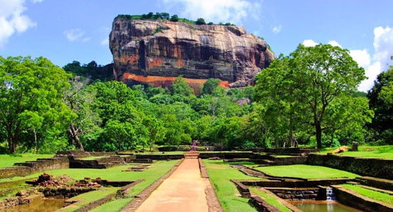
Sigiriya or Sinhagiri is an ancient rock fortress located in the northern Matale District near the town of Dambulla in the Central Province, Sri Lanka. The name refers to a site of historical and archaeological significance that is dominated by a massive column of rock nearly 200 metres (660 ft) high. According to the ancient Sri Lankan chronicle the Culavamsa, this site was selected by King Kasyapa (477 – 495 CE) for his new capital. On a small plateau about halfway up the side of this rock he built a gateway in the form of an enormous lion. Sigiriya today is a UNESCO listed World Heritage Site.
The Sigiriya site contains the ruins of an upper palace located on the flat top of the rock, a mid-level terrace that includes the Lion Gate and the mirror wall with its frescoes, the lower palaces located behind the lavish lower gardens, and moats and ramparts which protected the citadel. The site was both a palace and a fortress. The upper palace on the top of the rock includes cisterns cut into the rock. The moats and walls that surround the lower palace are exquisitely beautiful.
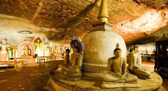
Dambulla is the largest and best-preserved cave temple complex in Sri Lanka situated in the central part of the country declare as a UNESCO World Heritage site in 1991. The rock towers 160 m over the surrounding plains.There are more than 80 documented caves in the surrounding area. Major attractions are spread over five caves, which contain statues and paintings. These paintings and statues are related to Gautama Buddha and his life. There are a total of 153 Buddha statues, three statues of Sri Lankan kings and four statues of gods and goddesses. The latter include Vishnu and the Ganesha. The murals cover an area of 2,100 square metres (23,000 sq ft). Depictions on the walls of the caves include the temptation by the demon Mara, and Buddha’s first sermon.
Prehistoric Sri Lankans would have lived in these cave complexes before the arrival of Buddhism in Sri Lanka as there are burial sites with human skeletons about 2700 years old in this area, at Ibbankatuwa near the Dambulla cave complexes.

Galle Fort, in the Bay of Galle on the southwest coast of Sri Lanka, was built first in 1588 by the Portuguese, then extensively fortified by the Dutch during the 17th century from 1649 onwards. It is a historical, archaeological and architectural heritage monument, which even after more than 423 years maintains a polished appearance, due to extensive reconstruction work done by Archaeological Department of Sri Lanka.
The fort has a colourful history, and today has a multi-ethnic and multi-religious population. The Sri Lankan government and many Dutch people who still own some of the properties inside the fort are looking at making this one of the modern wonders of the world. The heritage value of the fort has been recognized by the UNESCO and the site has been inscribed as a cultural heritage UNESCO World Heritage Site under criteria iv, for its unique exposition of “an urban ensemble which illustrates the interaction of European architecture and South Asian traditions from the 16th to the 19th centuries.”

116 km from Colombo is another fishing village known as Arugam Bay. Identified as the best surfing beach in Sri Lanka and the 4th best beach in South-East Asia and is also among the 10 best surfing beaches in the world. The Bird Santuary is also at close proximity to it so bird-watches / surf fanatics can spend a great time at the beach. Buddhist and hindu temples are also located closeby.

Located in east of the country 120 km from Colombo and 14 km from Trincomalee. The natural habour and beach is one of finest in world. Nelaveli is ideal place for water sports like scuba diving.
The best beach for whale and dolphin watching along with snorkeling amongst beautiful corals. Canoeing, sailing, wind surfing also take place along this beach. It’s a 3 hour drive from Colombo itself which is very convenient for tourists who stay in Colombo for the vacation. However Alankuda itself offers cottages and hotels along the beach for those who want to spend a romantic fun-filled day/night at this beautiful getaway. The Beach is paradise itself.

The famous fishing town located 35 km north of Colombo, very popular among locals for buying fresh sea food. Delicacies such as squid and lobsters are made in nearby hotels and restaurants , you can literally taste the ocean. It is one of the beaches with a long history where during the Dutch colonization churches and forts were built, most of these structures are still seen today.
Majority of beach parties in Sri Lanka are held here. Known for its great resorts lining the coast and sandy beaches situated 98 kilometers south of Colombo. Scuba diving is much in demand in Hikkaduwa because of its legendary coral gardens.

Is ranked as the 12th best best in the whole world. About 5 km south of Galle is the golden beach. It is one of the safest beaches in Sri Lanka since it is protected by a reef. Surfing, snorkeling & diving are some of the water sports you can do for recreation here.

The best beach for a romantic honeymoon or holiday. The most ideal place for water sports. Its located about 62 km sounth of Colombo.

The more popular place for beach parties since it is located pretty close to the commercial capital, Colombo. The beach is noted for its idyllic beauty and history. Beach sports such as , beach volleyball, windsurfing, beach rugby are very famous among the locals even. DJ nights take place frequently at MT Lavinia. proximity to the capital.

Situated 42 km south of Colombo. Kalutara is famous for it beach as well as for the Kalutara bodiya which is considered a sacred place for buddhist pilgrims. The best thing about the Kalutara beach is that the river is also at close proximities to it so sports like water rafting can be done.

Tangalle is located in down south district of Hamabanthota few km away from Mathara. It is known for its pearly sand and fishing harbour, the endless beach reflects serenity of the country that is Sri Lanka. Its one of the beaches which are famous for its coral reefs like Hikkaduwa.

Nuwara Eliya is a city in the hill country of the Central Province, Sri Lanka. Its name means “city on the plain (table land)” or “city of light”. The city is the administrative capital of Nuwara Eliya District, with a picturesque landscape and temperate climate. It is at an altitude of 1,868 m (6,128 ft) and is considered to be the most important location for tea production in Sri Lanka. The city is overlooked by Pidurutalagala, the tallest mountain in Sri Lanka. Nuwara Eliya is known for its temperate, cool climate — the coolest area in Sri Lanka.
The town’s attractions include the golf course, trout streams, Victoria Park, and boating or fishing on Lake Gregory. Victoria Park is an attractive and well-used oasis. It is popular with birdwatchers at quieter times because of the good opportunities for seeing species, particularly the Indian blue robin, pied thrush or scaly thrush lurking in the denser undergrowth. The Kashmir flycatcher is another attractive bird species in the park. S

Horton Plains National Park is a protected area in the central highlands of Sri Lanka and is covered by montane grassland and cloud forest. This plateau at an altitude of 2,100–2,300 metres (6,900–7,500 ft) is rich in biodiversity and many species found here are endemic to the region. This region was designated a national park in 1988. It is also a popular tourist destination and is situated 8 kilometres (5.0 mi) from Ohiya, 6 kilometres (3.7 mi) from the world famous Ohiya Gap/Dondra Watch and 32 kilometres (20 mi) from Nuwara Eliya.
The Horton Plains are the headwaters of three major Sri Lankan rivers, the Mahaweli, Kelani, and Walawe. In Sinhala the plains are known as Maha Eliya Plains. Stone tools dating back to Balangoda culture have been found here. The plains’ vegetation is grasslands interspersed with montane forest and includes many endemic woody plants. Large herds of Sri Lankan sambar deer feature as typical mammals and the park is also an Important Bird Area with many species not only endemic to Sri Lanka but restricted to the Horton Plains.

The Knuckles Mountain Range lies in central Sri Lanka, in the Districts of Matale and Kandy. The range takes its name from a series of recumbent folds and peaks in the west of the massif which resemble the knuckles of clenched fist when viewed from certain locations in the Kandy District. Whilst this name was assigned by early British surveyors, the Sinhalese residents have traditionally referred to the area as Dumbara Kanduvetiya meaning Mist-laden Mountain Range.
The higher montane area is often robed in thick layers of cloud. In addition to its aesthetic value, the range is of great scientific interest. It is a climatic microcosm of the rest of Sri Lanka as the conditions of all the climatic zones in the country are exhibited in the massif. At higher elevations there is a series of isolated cloud forests, harbouring a variety of flora and fauna. Although the range constitutes approximately 0.03% of the island’s total area, it is home to a significantly higher proportion of the country’s biodiversity. The isolated Knuckles range harbours several relict, endemic flora and fauna that are distinct from central massif. More than 34 percent of Sri Lanka’s endemic trees, shrubs, and herbs are only found in these forests. S

Ella is a beautiful small backpacker-hub on the southern edge of Sri Lanka’s Hill Country. It has become to go-to town in the hill country for tourists and as a result has a reasonably well-established tourism-orientated economy. For example, there is espresso coffee and fish and chips on offer, as well as lounge/backpacker -style bars aimed solely at the visitor.
It’s situated in the middle of beautiful countryside, with small vegetable plots in the valleys, tea plantations on the hill slopes and forests on the tops. The climate throughout most of the year is typical of the high Hill Country, with a hot sun by midday, but a moderate air temperature. It will often rain in the afternoon, but only for an hour or so. A sweatshirt, or light jacket is needed at night. In December it can rain a lot!
Walk up to Ella’s Rock, about 2 hours (each way) along the railway track and through the tea plantations, for stunning views across the countryside. The first 1.5km is along the railway track itself so keep an ear out for oncoming trains although they travel so slowly you’ll have plenty of time to get out of the way.

Kitulgala is a small town in the west of Sri Lanka. A rain forestry area, which gets two monsoons each year, and is one of the wettest places in Sri Lanka. Nevertheless, it comes alive in the first three months of the year, especially in February, the driest month. The Academy Award-winning movie The Bridge on the River Kwai was filmed on the Kelani River near Kitulgala, although nothing remains now except the concrete foundations for the bridge Kitulgala is the base for white-water rafting in Sri Lanka.
Large numbers of people make the excursion from Colombo at weekends to enjoy the beautiful scenery, play in the river, Jungle Walks, Adventurous water fall jumps/ slides, White Water Rafting and have an excellent rice and curry lunch at the local restaurants.This area has most of the rainforest bird species that are found at the World Biosphere Reserve at Sinharaja, although in lower numbers. However, the secondary forest and cultivation at Kitulgala is more open than the pristine woodlands of Sinharaja, and elusive endemic species like Sri Lanka Spurfowl, Green-billed Coucal and Spot-winged Thrush may be easier to see. So Kitulgala is a primary spot for bird watching enthusiasts.
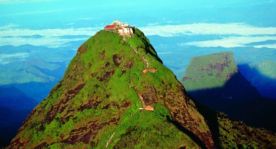
Adam’s Peak – Sri Pada or Samanalakanda, (Butterfly Mountain) is a 2,243 m (7,359 ft) tall conical mountain located in central Sri Lanka. It is well known for the Sri Pada, “sacred footprint” rock formation near the summit, which in Buddhist tradition is held to be the footprint of the Buddha, in Hindu tradition that of Shiva and in Islamic and Christian tradition that of Adam, or that of St. Thomas. Adam’s Peak is important as a watershed. The districts to the south and the east of Adam’s Peak yield precious stones—emeralds, rubies and sapphires, for which the island has been famous, and which earned for its ancient name of Ratnadvipa.
The pilgrims season to Sri Pada traditionally starts on the full moon of December and ends on the full moon of April . It takes a while for the crowds to build up but by the second half of the season they can be very large so it is best to go earlier. Weekends and particularly full moon days are always crowded and should be avoided. Most people make the climb at night so they can arrive in time for the sunrise.Access to the mountain is possible by 6 trails: Ratnapura-Palabaddala, Hatton-Nallathanni, Kuruwita-Erathna, Murraywatte, Mookuwatte & Malimboda. The usual route taken by most pilgrims is ascent via Hatton and descent via Ratnapura; although the Hatton trail is the steepest, it is also shorter than any of the other trails by approximately five kilometers.

Yala National Park is the most visited and second largest national park in Sri Lanka. The park consists of five blocks, two of which are now open to the public, and also adjoining parks. The blocks have individual names such as, Ruhuna National Park (block 1) and Kumana National Park or ‘Yala East’ for the adjoining area. It is situated in the southeast region of the country, and lies in Southern Province and Uva Province. The park covers 979 square kilometres (378 sq mi) and is located about 300 kilometres (190 mi) from Colombo. Yala was designated as a wildlife sanctuary in 1900, and, along with Wilpattu was one of the first two national parks in Sri Lanka, having been designated in 1938. The park is best known for its variety of wild animals. It is important for the conservation of Sri Lankan elephants, Sri Lankan leopards and aquatic birds.

Wilpattu National Park (Willu-pattu; Land of Lakes) is a park located on the island of Sri Lanka. The unique feature of this park is the existence of “Willus” (Natural lakes) – Natural, sand-rimmed water basins or depressions that fill with rainwater. Located in the Northwest coast lowland dry zone of Sri Lanka. The park is located 30 km west Anuradhapura and located 26 km north of Puttalam (approximately 180 km north of Colombo). The park is 1,317 square kilometers (131, 693 hectares) and ranges from 0 to 152 meters above sea level. Nearly sixty lakes (Willu) and tanks are found spread throughout Wilpattu. Wilpattu is the largest and one of the oldest National Parks in Sri Lanka. Sri Lanka Wildlife Sanctuaries

Udawalawe National Park lies on the boundary of Sabaragamuwa and Uva Provinces, in Sri Lanka. The national park was created to provide a sanctuary for wild animals displaced by the construction of the Udawalawe Reservoir on the Walawe River, as well as to protect the catchment of the reservoir. The reserve covers 30,821 hectares (119.00 sq mi) of land area and was established on 30 June 1972. Before the designation of the national park, the area was used for shifting cultivation (chena farming). The farmers were gradually removed once the national park was declared. The park is 165 kilometres (103 mi) from Colombo. Udawalawe is an important habitat for water birds and Sri Lankan elephants. It is a popular tourist destination and the third most visited park in the country.
Udawalawe is an important habitat for Sri Lankan elephants, which are relatively hard to see in its open habitats. Many elephants are attracted to the park because of the Udawalawe reservoir, with a herd of about 250 believed to be permanently resident. The Udawalawe Elephant Transit Home was established in 1995 for the purpose of looking after abandoned elephant calves within the park. A total of nine calves, on two occasions in 1998 and 2000, with another eight calves in 2002, were released in the park when old enough to fend for themselves. Sri Lanka Wildlife Sanctuaries

Minneriya National Park is a national park in North Central Province of Sri Lanka. The area was designated as a national park on 12 August 1997, having been originally declared as a wildlife sanctuary in 1938. The reason for declaring the area as protected is to protect the catchment of Minneriya tank and the wildlife of the surrounding area. The tank is of historical importance, having been built by King Mahasen in third century AD. The park is a dry season feeding ground for the elephant population dwelling in forests of Matale, Polonnaruwa, and Trincomalee districts. The park earned revenue of Rs. 10.7 millions in the six months ending in August 2009. Along with Kaudulla and Girithale, Minneriya forms one of the 70 Important Bird Areas (IBAs) of Sri Lanka.
The area is situated in dry zone of Sri Lanka and receives an average rainfall of 1,500–2,000 millimetres (59–79 in). The wet season lasts during the north eastern monsoon from October to January and from May to September considered as the dry season. Large numbers of Sri Lankan elephants are attracted to grass fields on the edges of the reservoir during the dry season. The Minneriya tank contributes to sustain a large herd. Elephants gathered here is numbering around 150-200. Some reports account number of elephants to as high as 700. They migrate here from Wasgamuwa National Park and benefit from food and shelter of the park’s forest. Tourists visit Minneriya largely because of elephants, especially in dry season.
- Wildlife and Beach Tour Itinerary Sri Lanka: 12 Days for UK Travellers in 2026
- Ramayana tour Sri Lanka for Indians
- Trusted Tour Operator in Sri Lanka for Authentic Local Travel
- Sri Lanka Classic Escape- Ramayana Trail
- Sri Lanka Tour Guide – Your Friendly Companion for an Unforgettable Journey
- Private Tour Guide in Sri Lanka – Your Personal Gateway to the Island’s Best Kept Secret
- Luxury Honeymoons in Sri Lanka – Hidden Escapes & Timeless Romance
- Horton Plains National Park – Trails, Wildlife & Travel Tips
- Sri Lankan Tour Guide – Travel in Sri Lanka with your friendly tour guide
- Why Choose a Tour Guide with Driver in Sri Lanka?
- 10 reasons why you should hire a private tour guide in Sri Lanka
- Local Tour Guide in Sri Lanka – Travel Smart with a Friendly Local Expert
- HONEYMOON SRI LANKA
- Sri Lanka Travel Guides – Everything You Need Before Your Trip
- Sri Lankan Travel Destinations – Where to Go and Why It Matters
- 2025 Licensed Tour Guide Sri Lanka – Cultural & Tourist Board Guides Overview
- Cultural Travel Guides Sri Lanka – Explore Heritage with Licensed Local Experts
- Looking for an Affordable Sri Lankan Adventure? Explore These Top 5 Budget-Friendly Tours in the Cultural Triangle
- How to Find the Best Sri Lankan Tour Guide for Your Dream Trip
- Private Tour Guide Sri Lanka